The road from Joshimath to Badrinath remains one of the most important pilgrimage routes in Uttarakhand. Every year, lakhs of pilgrims travel this road to reach Badrinath Dham. The road between Joshimath and Badrinath is currently facing delays and local closures. Due to recent weather warnings and heavy rains, thunderstorms, and possible landslides. If you plan to travel this route, you must know the latest updates before you go.
The route is a lifeline for the region. It remains vulnerable to nature's fury. This blog provides the latest road conditions, weather alerts, traffic updates, safety tips and Char Dham Yatra travel advice. If you plan to visit the holy shrine of Badrinath, you must stay informed.
Recently, the IMD issued an orange alert for Uttarakhand. This warning specifically applies to the Chamoli district. Chamoli is home to the vital Badrinath National Highway. The alert is valid for the next 36 hours. At present, weather warnings for heavy rain, thunderstorms, and possible landslides create concern among pilgrims and tourists. Therefore, many travellers now want the latest Joshimath to Badrinath road update before starting their journey.
Authorities are continuously monitoring the route. The Border Roads Organisation (BRO) and local administration are also working to keep the highway operational after weather warnings. Still, weather in the mountains changes very quickly, which raises the risk of landslides and road blockages on the Badrinath route. Because of this, road conditions may change within a few hours.
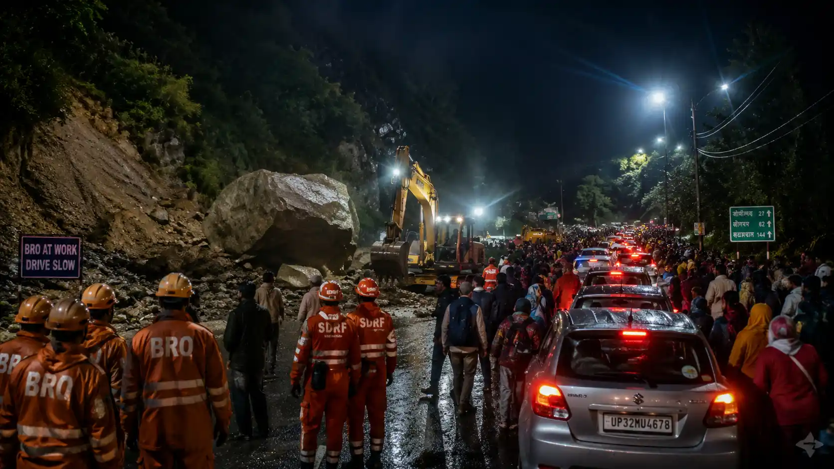
You may already know about this recent disaster. Due to heavy rainfall, a massive landslide occurred near the Munkatiya area in Rudraprayag district. As a result, the Sonprayag-Gaurikund route was completely blocked, leaving around 10,450 Kedarnath pilgrims stranded. The Kedarnath route landslide rescue operation 2026 became one of the biggest emergency rescue efforts during this year’s yatra season. However, the quick response from the SDRF, NDRF, police teams, and local administration helped save thousands of lives safely.
The forecast predicts heavy rain and gusty winds. Hailstorms might also occur in various parts. Furthermore, higher altitudes may witness fresh snowfall. The wind speed could reach 40-50 kilometres per hour. Such conditions make the hilly terrain extremely unstable.
The India Meteorological Department (IMD) recently issued warnings for several districts of Uttarakhand, including Chamoli district. Heavy rain, hailstorms, thunderstorms, and strong winds were expected in many hill regions. The weather near Badrinath is currently cold and unstable. Light rain and thunderstorms are expected in some areas around the temple region. Temperatures are also low during morning and night hours.
The Joshimath–Badrinath stretch is highly prone to landslides. The mountains in this zone are geologically fragile. When heavy rain falls, rocks and boulders break loose from the slopes and crash onto the road. This happens without warning and blocks traffic instantly. Day temperatures may stay between 15°C and 18°C, while night temperatures can fall below 6°C in higher areas.
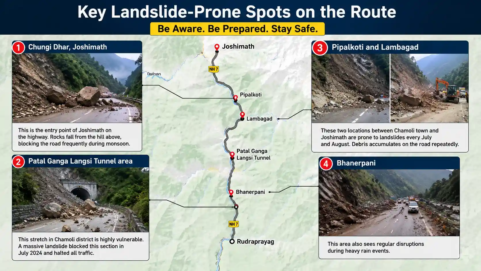 Key Problematic Stretches to Watch Out For
If you must travel, avoid specific black spots. These areas are notorious for rough travel:
Lambagad Area: Highly prone to falling pebbles and debris.
Kanchan Nala: The road surface here is severely damaged.
Parthadeep Landslide Zone: Authorities are working on stabilisation, but the 20-metre stretch is in extremely bad shape.
Pinola near Govindghat: Large boulders have previously rolled down here, blocking the entire highway.
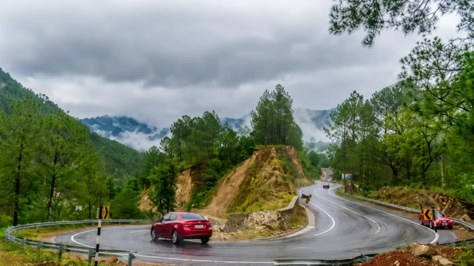
The route from Joshimath to Badrinath spans roughly 45 kilometres [National Highway 58 (NH58)]. Under normal conditions, this drive takes about two hours. However, current challenges require extra time and extreme care. Some sections are narrow and sensitive to landslides. During heavy rain, debris often falls on the highway.
This initial stretch is currently the most problematic section. Due to the historical ground subsidence issues in Joshimath town, the local administration enforces a strict speed limit of 30 km/h. Furthermore, the road between Joshimath and Marwadi suffers from heavy debris accumulation. Recent construction and unstable slopes have left unpaved patches and deep potholes. Rain makes this section highly slushy and uncomfortable.
Lambagad was once the most dreaded bottleneck on the entire highway. The All-Weather Road project has built protective sheds and walls here. Despite these upgrades, Lambagad remains a sensitive rockfall area. When heavy rain hits, small pebbles begin to roll down the hillsides. If you notice falling debris, stop your vehicle at a safe distance immediately. Do not attempt to rush through.
Kanchan Nala is a natural seasonal stream that crosses the highway. During sudden cloudbursts or heavy downpours, the water level in this stream rises rapidly. The flowing water washes mud and boulders onto the road. Border Roads Organisation (BRO) personnel monitor this spot continuously. They deploy heavy earthmovers to clear the path whenever the stream overflows.
The road near Pipalkoti has loose gravel on the surface. Drivers lose traction easily on these small stones. Moving closer to Govindghat, the road is relatively wider, but visibility drops quickly when clouds descend on the valley.
If you travel this road, you must know which sections carry the highest risk. Several stretches regularly face landslides and blockages.
Therefore, even when the highway appears open at one point, it may still be blocked further ahead. Always check multiple sections before you travel.
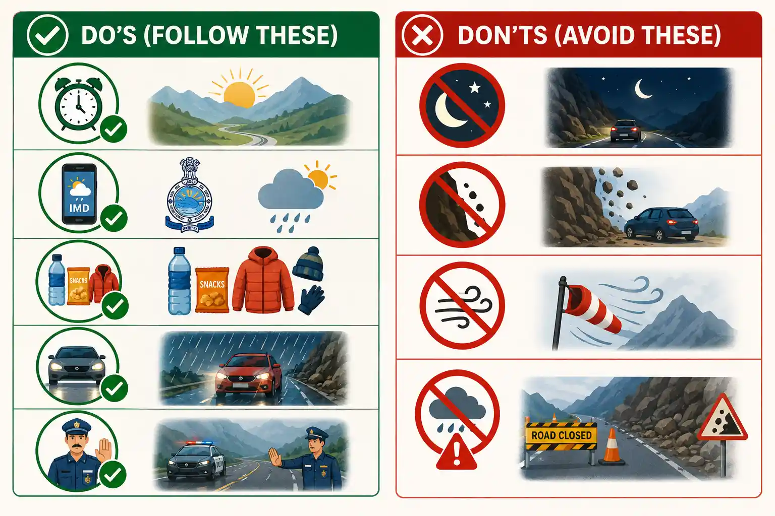 Do's (Follow These)<
Yes, the route is currently open. However, travellers must stay alert because weather conditions may change suddenly in the Himalayas. So, caution is required. Check for local updates. Only if the weather is clear. Otherwise, postpone the trip. The jerks and bumps can be very taxing.
The safest travel time for the Joshimath–Badrinath route falls between May and mid-June and again in October. During these months, weather conditions are generally clear. Rain is less frequent. Landslide risk drops significantly.
In contrast, July and August bring the heaviest monsoon rain. Landslides happen frequently. Road closures are common. If you must travel during this period, check updates every morning and remain flexible about your plans.
September can also bring surprises. Recent years have shown increasing weather instability in September, with unpredictable heavy rain events disrupting travel even after the peak monsoon period ends.
The Joshimath to Badrinath road is currently open, but weather conditions continue to affect travel in the Himalayan region. Heavy rain, landslides, and traffic congestion remain major concerns during the Char Dham Yatra season. Plan with buffer days in your itinerary. Book flexible accommodations and avoid tight return schedules that leave no room for a weather delay.
Always check the latest IMD weather alerts, BRO road status updates, and local news before you set out. Travel during daylight, carry essentials, and listen to authorities. If conditions turn unsafe, wait patiently. No pilgrimage is worth risking your life.
Our Packages: Luxury Chardham Yatra Package | Chardham Yatra Package by Helicopter | Do Dham Yatra Package | Chardham Yatra Family Package | Chardham Yatra Package from Haridwar | Chardham Yatra Package from Delhi
Badrinath Dham will welcome you when the time is right. Travel safely, and may your yatra be blessed.